![](/images/other/stat-length.png)
![Tocht Te voet Gouveia (São Simão) - Trilho dos Caminhos de Água - Photo](https://media.geolcdn.com/t/1900/400/ext.pjpeg?maxdim=2&url=https%3A%2F%2Fstatic1.geolcdn.com%2Fsiteimages%2Fupload%2Ffiles%2F1545311037marcheuse_200dpi.jpg)
Trilho dos Caminhos de Água
SityTrail - itinéraires balisés pédestres
Tous les sentiers balisés d’Europe PRO
![Lengte](/images/other/stat-length.png)
Lengte
10,4 km
![Max. hoogte](https://static1.geolcdn.com/siteimages/upload/files/1508320355ic_sort_altitude_max_24dp.png)
Max. hoogte
947 m
![Positief hoogteverschil](https://static1.geolcdn.com/siteimages/upload/files/1508320355ic_sort_den_pos_24dp.png)
Positief hoogteverschil
272 m
![Km-Effort](/images/other/stat-length.png)
Km-Effort
14,1 km
![Min. hoogte](https://static1.geolcdn.com/siteimages/upload/files/1508320355ic_sort_altitude_min_24dp.png)
Min. hoogte
719 m
![Negatief hoogteverschil](https://static1.geolcdn.com/siteimages/upload/files/1508320355ic_sort_den_neg_24dp.png)
Negatief hoogteverschil
271 m
![Boucle](https://static1.geolcdn.com/siteimages/upload/files/16400158638029165_repeat_loop_refresh_sync_direction_icon.png)
Boucle
Ja
Markering
Datum van aanmaak :
2022-02-14 14:43:56.716
Laatste wijziging :
2022-02-14 14:43:56.716
![Te voet](https://static1.geolcdn.com/sitytour/trail-icons/100.png)
3h11
Moeilijkheid : Gemakkelijk
![Scan deze QR-code om de tocht te openen in de SityTrail-applicatie](https://capi.geolives.com/qq0zvz2zws4bq2lad0pu/sitytour/trails/3109154/qr.png?size=200)
Gratisgps-wandelapplicatie
Over ons
Tocht Te voet van 10,4 km beschikbaar op Norte, Porto, Gouveia (São Simão). Deze tocht wordt voorgesteld door SityTrail - itinéraires balisés pédestres.
Beschrijving
Website: http://www.baixotamega.pt/frontoffice/pages/532?geo_article_id=2132
Plaatsbepaling
Land:
Portugal
Regio :
Norte
Departement/Provincie :
Porto
Gemeente :
Gouveia (São Simão)
Locatie:
Unknown
Vertrek:(Dec)
Vertrek:(UTM)
580787 ; 4562649 (29T) N.
Opmerkingen
Wandeltochten in de omgeving
![Tocht Te voet Soalhães - Pedras, Moinhos e Aromas de Santiago - Photo](https://media.geolcdn.com/t/375/260/ext.jpg?maxdim=2&url=https%3A%2F%2Fmedia.geolcdn.com%2Ff%2F214827ee-eb0e-4694-b660-7a811aa07bdf.jpeg)
![Te voet Te voet](https://static1.geolcdn.com/sitytour/trail-icons/100.png)
Pedras, Moinhos e Aromas de Santiago
Te voet
Gemakkelijk
Soalhães,
Norte,
Porto,
Portugal
![](/images/other/stat-length.png)
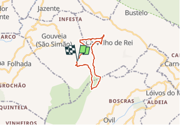
7,6 km | 11 km-effort
2h 30min
![](https://static1.geolcdn.com/siteimages/upload/files/16400158638029165_repeat_loop_refresh_sync_direction_icon.png)
Neen
![Tocht Te voet Campelo e Ovil - Trilho das Florestas Naturais - Photo](https://media.geolcdn.com/t/375/260/ext.jpg?maxdim=2&url=https%3A%2F%2Fmedia.geolcdn.com%2Ff%2Fbe490312-82fc-446b-b203-500621928578.jpeg)
![Te voet Te voet](https://static1.geolcdn.com/sitytour/trail-icons/100.png)
Trilho das Florestas Naturais
Te voet
Gemakkelijk
Campelo e Ovil,
Norte,
Porto,
Portugal
![](/images/other/stat-length.png)
11,9 km | 18,4 km-effort
4h 10min
![](https://static1.geolcdn.com/siteimages/upload/files/16400158638029165_repeat_loop_refresh_sync_direction_icon.png)
Ja
![Tocht Te voet Várzea, Aliviada e Folhada - Trilho dos Dólmens - Photo](https://media.geolcdn.com/t/375/260/ext.jpg?maxdim=2&url=https%3A%2F%2Fstatic1.geolcdn.com%2Fsiteimages%2Fupload%2Ffiles%2F1545311037marcheuse_200dpi.jpg)
![Te voet Te voet](https://static1.geolcdn.com/sitytour/trail-icons/100.png)
Trilho dos Dólmens
Te voet
Gemakkelijk
Várzea, Aliviada e Folhada,
Norte,
Porto,
Portugal
![](/images/other/stat-length.png)
11,2 km | 15,1 km-effort
3h 26min
![](https://static1.geolcdn.com/siteimages/upload/files/16400158638029165_repeat_loop_refresh_sync_direction_icon.png)
Ja